Home
|
About this project
|
Contact
Background
Key concepts
What is NGLA?
Basic facts about NGLA
What is karst?
Glossary of terms
Geographic Area
Overview
General geology
General hydrology
Climate
Soil
Vegetation
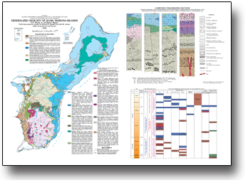
Geology
Overview
Limestone units
Barrigada Limestone
Mariana Limestone
Argillaceous Member
Volcanic units
Other units
Hydrology
Overview
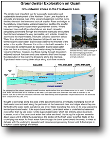
Lens zones
Vadose zone
Phreatic zone
Mixing zone
Aquifer "plumbing"
Recharge
Water pathways
Discharge
Water quality
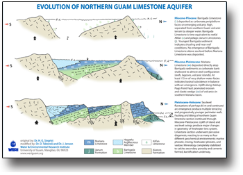
Karst
Overview
Carbonate island karst
Karst features
Epikarst
Sinkholes
Caves
Springs
Coastal geomorphology
Environment
Overview
Forests
Scrub
Savanna
Cliffs
Beaches
Reefs
Population
Overview
Municipalities
Military lands
Protected areas
Infrastructure
Northern Guam geospatial information server
Project documentation
This page provides access to documents that describe the nature and purpose of this project.
Download:
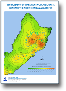
Basement Topography of the NGLA
Exploration in the NGLA
Geology and Stratigraphy of Guam
Evolution of the NGLA
Petrographic summary of key NGLA limestone units
Maps
Topography
Northern Guam limits
Physiography
10-m contours
10-m contours, color
50-m contours
50-m contours, color
Elevation intervals
Elevation range, color
Elevation range, grey
Shaded relief
Shaded relief + elevation
USGS topographic map
Slope aspect
Slope, in degrees
Slope, in percent
Cliffline
Cliffline + shaded relief
Satellite image
Geology
Detailed geology
General geology
Simple geology
Sandy beaches
Reef flats
Structural geology
Structural, simplified
Pago-Adelup fault
Geologic map raster
Climate
Rainfall distribution
Rain gages and weather data stations
Soil
Detailed map of soils
General map of soils
Simple map of soils
Drainage
Rivers
Aquifer recharge areas
Pervious vs. imprevious surfaces
Ponding basins
Sinkhole locations
Closed depressions, contours
Closed depressions, polygons
Surface flowpaths
Surface drainage basins
Caves
Coastal discharge
Perched springs
Elevation contours of the volcanic basement
Elevation range of the volcanic basement
Shaded relief of the volcanic basement
Basement zero contour
Basement drainage basin areas
Basement drainage basin divides
Basement drainage basin discharge margins
Groundwater
Basal and parabasal groundwater
Production wells
Observation wells
Injection wells
Bedrock conductivity
Water table elevation
Caves with water table
Chloride content
Land surface of the NGLA
Subsurface of the NGLA
Land cover
Detailed 2004 landcover
Detailed 2011 landcover
General 2011 landcover
Bare land
Cultivated land
Wetlands
Marine
Benthic habitat detailed
Bottom cover
Bottom structure
Bottom structure, simple
Offshore bathymetry
Population
Populated areas
Municipalities
Population density
Placenames
Protected areas
Urban buildup
Infrastructure
Routes and streets
Buildings
Military areas
Geospatial data
ON-LINE MAP VIEWER
Data files for GIS
Data files for Google Earth
Download software
Photo galleries
Landscapes
Features
Aerials
Maps gallery
Publications
Project documentation
Summaries and handouts
Field trip guides
WERI, USGS, and EPA reports
Outside links
WERI
IREI
GovGuam
GovGuam BSP
USGS
NOAA
NOAA OCRM